
File:Sani Pass heading into Lesotho.jpg
原本檔案 (1,600 × 1,063 像素,檔案大細:2.24 MB ,MIME類型:image/jpeg)
摘要
| 描述 |
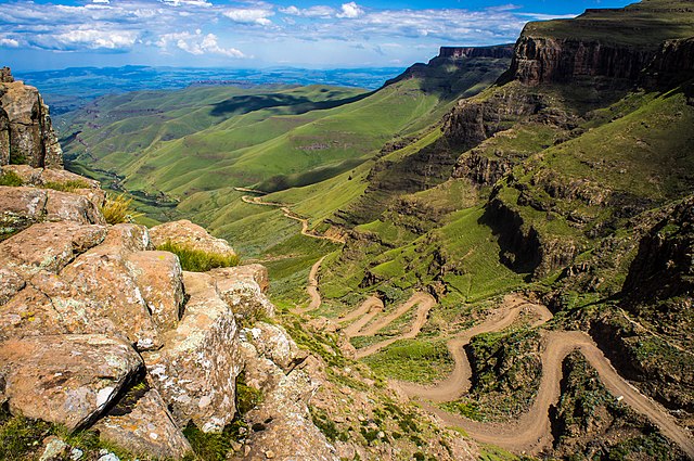
English: The road through Sani Pass taken from the rim of Drakensberg Escarpment within 100 metres of the South African/Lesotho border. |
| 日期 | |
| 來源 | Flickr: Sani Pass |
| 作者 | Vaiz Ha |
| Camera location | | View this and other nearby images on: OpenStreetMap |
|---|
Geo-coords added by Martinvl after comparison of image with Google Earth.
協議
| This image was originally posted to Flickr by Vaiz Ha at https://www.flickr.com/photos/93708644@N05/8523139565. It was reviewed on 2015年3月11號 by FlickreviewR and was confirmed to be licensed under the terms of the cc-by-2.0. |
Ĉi tiu dosiero estas disponebla laŭ la permesilo Krea Komunaĵo Atribuite 2.0 Ĝenerala.
姓名標示: Vaiz Ha
- 你可以:
- 去分享 – 複製、發佈同傳播呢個作品
- 再改 – 創作演繹作品
- 要遵照下面嘅條件:
- 署名 – 你一定要畀合適嘅表彰、畀返指向呢個授權條款嘅連結,同埋寫明有無改過嚟。你可以用任何合理方式去做,但唔可以用任何方式暗示授權人認可咗你或者你嘅使用方式。

|
This image has been assessed under the valued image criteria and is considered the most valued image on Commons within the scope: Road up the Sani Pass, South Africa heading towards the Lesotho border.. You can see its nomination here. |
檔案歷史
撳個日期/時間去睇響嗰個時間出現過嘅檔案。
| 日期/時間 | 縮圖 | 尺寸 | 用戶 | 註解 | |
|---|---|---|---|---|---|
| 現時 | 2015年3月11號 (三) 21:24 |  | 1,600 × 1,063(2.24 MB) | Alifazal | User created page with UploadWizard |
檔案用途
無嘢連來呢份檔案。
全域檔案使用情況
下面嘅維基都用緊呢個檔案:
- af.wikipedia.org嘅使用情況
- bh.wikipedia.org嘅使用情況
- bn.wikipedia.org嘅使用情況
- ca.wikipedia.org嘅使用情況
- ceb.wikipedia.org嘅使用情況
- de.wikipedia.org嘅使用情況
- en.wikipedia.org嘅使用情況
- Mountain pass
- Sani Pass
- User talk:InfamousArgyle
- User talk:Mathwhiz 29
- User talk:Whiteghost.ink
- User talk:C6541/Archives
- User talk:Sahara4u
- User talk:Sarason
- User talk:Smileguy91
- User talk:Hypoplectrus
- User talk:Pratyya Ghosh
- User talk:Gwooodward
- User talk:Human3015
- User talk:Khamar
- User talk:Joshualouie711
- User talk:OfficialNeon
- User talk:Mozby
- User talk:MoarSmtp
- User talk:VictorTorres2002/Archive 3
- User talk:Mitchellhobbs/Archives/1
- User talk:TheDragonHypothesis
- User talk:Vanilla Wizard/Archive 1
- User talk:VictorTorres2002/Archive 5
- User talk:Esquivalience/Archive 15
- User talk:MusikAnimal/Archive 42
- User talk:ChamithN/Archive 32
- User talk:Winner 42/Archive 25
- User talk:Bananasoldier/Archive 9
- User talk:TruthToBeSpoken/Archive 6
- User talk:CAPTAIN RAJU/Archive 98
- User talk:K6ka/Archive 27
- User talk:Silver seren/Archive 25
- User talk:BabbaQ/Archive 11
- User talk:Mahensingha/Archive 54
- User talk:Sanskari/Archive 109
- User talk:KGirlTrucker81/Signpost/Archive 17
- User talk:Hhkohh/Archive 6
- User talk:7&6=thirteen/Archive 15
- User talk:NorthwestPassage/Archive 5
- Wikipedia talk:Articles for improvement/Archive 24
睇呢個檔案嘅更多全域使用情況。