
File:Map of the Faroe Islands en.svg

呢個「SVG」檔案嘅呢個「PNG」預覽嘅大細:457 × 600 像素。 第啲解像度:183 × 240 像素|366 × 480 像素|585 × 768 像素|780 × 1,024 像素|1,561 × 2,048 像素|1,683 × 2,208 像素。
原本檔案 (SVG檔案,表面大細: 1,683 × 2,208 像素,檔案大細:763 KB)
摘要
| 描述 |
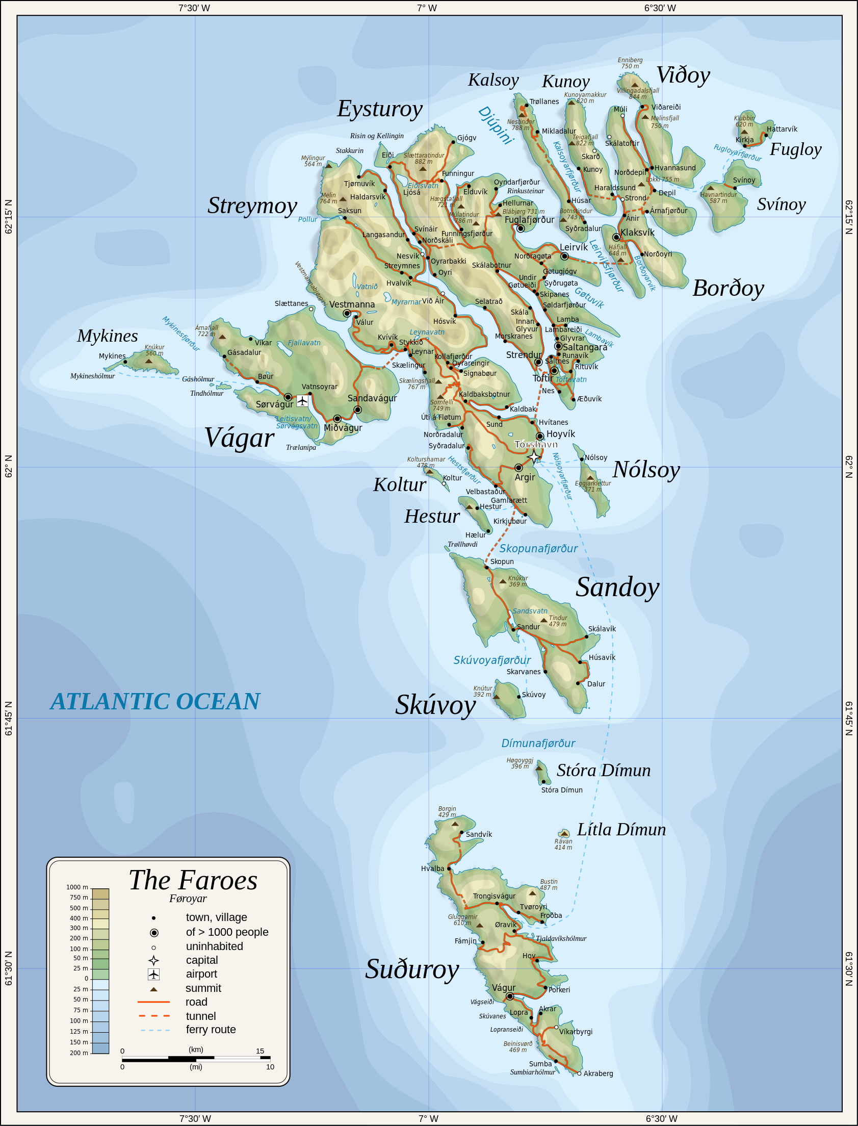
English: Topographic map of the Faroe Islands.
Suomi: Färsaarten topografinen kartta.
Coastline, roads, place names, and summits based partly on File:Faroe map with villages, streets, straits, firths, ferry harbours and major moutains.png. Topography based on public domain GLOBE data from NOAA (http://www.ngdc.noaa.gov/mgg/topo/gltiles.html). Relief shading is an embedded PNG raster, derived from ETOPO2 data. Bathymetry from NGDC ETOPO2 (low resolution raster with a "blur" property). |
| 日期 | 2009-01-28, 2024-02-11 |
| 來源 | 自己作品 |
| 作者 | Oona Räisänen |
| Other versions |
Derivative works of this file: |
| SVG genesis |
協議
Oona Räisänen (Mysid), the copyright holder of this work, hereby publishes it under the following licenses:
呢個檔案用共享創意 姓名標示-非商業性-相同方式分享3.0 未本地化版本條款授權。
姓名標示: Oona Räisänen (Mysid)
- 你可以:
- 去分享 – 複製、發佈同傳播呢個作品
- 再改 – 創作演繹作品
- 要遵照下面嘅條件:
- 署名 – 你一定要畀合適嘅表彰、畀返指向呢個授權條款嘅連結,同埋寫明有無改過嚟。你可以用任何合理方式去做,但唔可以用任何方式暗示授權人認可咗你或者你嘅使用方式。
- 相同方式分享 – 如果你用任何方式改過呢個作品,你必須要用返原本或者相似嘅條款發佈。

|
根據自由軟體基金會發佈嘅無固定段落、封面文字同封底文字GNU自由文件授權條款第1.2或打後嘅版本,你獲授權可以重製、散佈同埋修改爾份文件。授權條款嘅副本喺章節GNU自由文件授權條款。 |
你可以揀你想用嘅牌照。
檔案歷史
撳個日期/時間去睇響嗰個時間出現過嘅檔案。
| 日期/時間 | 縮圖 | 尺寸 | 用戶 | 註解 | |
|---|---|---|---|---|---|
| 現時 | 2024年2月11號 (日) 20:53 | | 1,683 × 2,208(763 KB) | Mysid | 'Multiply' blend mode didn't work - trying with alpha channel. |
| 2024年2月11號 (日) 20:34 |  | 1,683 × 2,208(733 KB) | Mysid | Added new 2023 tunnel, new names of some villages, fixed mistakes and svg errors, details | |
| 2010年7月19號 (一) 09:18 |  | 1,683 × 2,208(539 KB) | Mysid | oops, legend missing | |
| 2010年7月19號 (一) 09:16 |  | 1,683 × 2,208(539 KB) | Mysid | better choices for fonts | |
| 2009年1月28號 (三) 19:22 |  | 1,683 × 2,208(694 KB) | Mysid | remove ext. images | |
| 2009年1月28號 (三) 19:21 |  | 1,683 × 2,208(694 KB) | Mysid | embed all rasters | |
| 2009年1月28號 (三) 18:52 |  | 1,683 × 2,208(653 KB) | Mysid | {{Information |Description={{en|1=Topographic map of the Faroe Islands.}} |Source=Own work by uploader |Author=Mysid |Date=2009-01-28 |Permission= |other_versions= }} <!--{{ImageUpload|full}}--> Category:Maps of the Faroe Islands |
檔案用途
以下嘅1版用到呢個檔:
全域檔案使用情況
下面嘅維基都用緊呢個檔案:
- bg.wikipedia.org嘅使用情況
- bn.wikipedia.org嘅使用情況
- dsb.wikipedia.org嘅使用情況
- el.wikipedia.org嘅使用情況
- en.wikipedia.org嘅使用情況
- es.wikipedia.org嘅使用情況
- fa.wikipedia.org嘅使用情況
- fi.wikipedia.org嘅使用情況
- fo.wikipedia.org嘅使用情況
- frr.wikipedia.org嘅使用情況
- fr.wikipedia.org嘅使用情況
- ga.wikipedia.org嘅使用情況
- hu.wikipedia.org嘅使用情況
- ia.wikipedia.org嘅使用情況
- is.wikipedia.org嘅使用情況
- it.wikipedia.org嘅使用情況
- ka.wikipedia.org嘅使用情況
- kk.wikipedia.org嘅使用情況
- ko.wikipedia.org嘅使用情況
- lb.wikipedia.org嘅使用情況
- lez.wikipedia.org嘅使用情況
- mi.wikipedia.org嘅使用情況
- mk.wikipedia.org嘅使用情況
- nl.wikipedia.org嘅使用情況
- ru.wikipedia.org嘅使用情況
- scn.wikipedia.org嘅使用情況
- sco.wikipedia.org嘅使用情況
- sc.wikipedia.org嘅使用情況
- sr.wikipedia.org嘅使用情況
- sv.wikipedia.org嘅使用情況
睇呢個檔案嘅更多全域使用情況。